Did you ever think about where an artificial satellites is orbiting. Or are do you just have a need to know where satellites are positioned at any given moment? . Or what satellites are above you head ?
yes I too like to track the satellites. we all can do it.
yes I too like to track the satellites. we all can do it.
 To Define the apparent position of an object in the sky. Usually a satellite,planet or moon with respective point on the ground. We need two parameters.
1) azimuth(az) angle
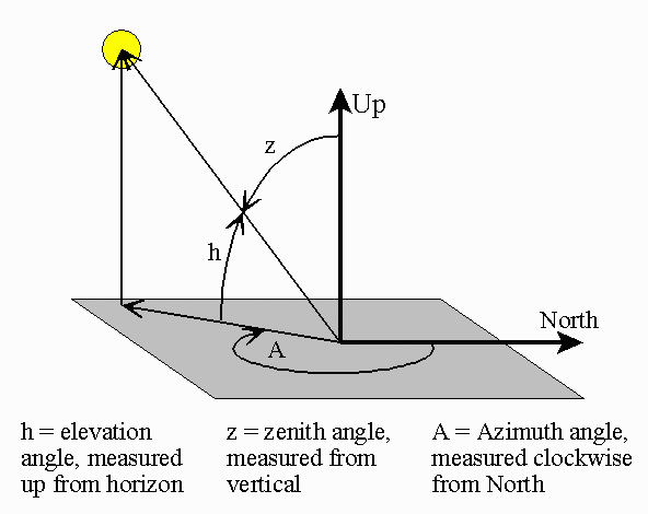
The azimuth (az) angle is the compass bearing, relative to true (geographic) north, of a point on the horizon directly beneath an observed object. The horizon is defined as a huge, imaginary circle centered on the observer, equidistant from the zenith (point straight overhead) and the nadir (point exactly opposite the zenith). As seen from above the observer, compass bearings are measured clockwise in degrees from north. Azimuth angles can thus range from 0 degrees (north) through 90 (east), 180 (south), 270 (west), and up to 360 (north again).
2) Elevation(el) angle
The elevation (el) angle, also called the altitude, of an observed object is determined by first finding the compass bearing on the horizon relative to true north, and then measuring the angle between that point and the object, from the reference frame of the observer. Elevation angles for objects above the horizon range from 0 (on the horizon) up to 90 degrees (at the zenith). Sometimes the range of the elevation coordinate is extended downward from the horizon to -90 degrees (the nadir). This is useful when the observer is located at some distance above the surface, such as in an aircraft.
Now you need another two parameters to locate your ground station.
Longitude and latitude. You can simply find them in Google earth.
So if you know the azimuth and elevation angle with respective our ground station, we can easily point out the satellite in our visible sky.
Today I googled and found a free real-time satellite tracking software. GPREDICT.
Gpredict is a real-time satellite tracking and orbit prediction application. It can track an unlimited number of satellites and display their position and other data in lists, tables, maps, and polar plots (radar view). Gpredict can also predict the time of future passes for a satellite, and provide you with detailed information about each pass.

Screen shot of GPREDICT
Video
Video
No comments:
Post a Comment
Please Do not for get to comment